Finalize and adopt the plan based on the extensive analysis and stakeholder feedback garnered throughout the process.
The transportation projects included in the 2015-2040 Regional Transportation Plan (RTP) are planned to meet the travel needs and improve the quality of life within the Wasatch Front region for the next 30 years. The Wasatch Front Regional Council (WFRC) developed project lists with residents, local government stakeholders, and partner agencies by collecting project ideas and testing them against the RTP goals. To be implemented, the region will need both existing and additional transportation revenues. For additional information regarding the revenues, visit the “Select Projects and Phase” page.
In addition to regional road, transit, and bicycle improvements, the 2015-2040 RTP also recommended general policy for transportation systems, enhancements, regional freight movement, safety, preservation and maintenance, and homeland security. The RTP conformed to federal air quality standards, meaning that the vehicle emissions estimated for the year 2040 are within the limits identified in the State Implementation Plan (SIP).
The interactive map contains all of the roadway, transit, and bike projects proposed for the 2015-2040 RTP. Users can view the project phasing by turning layers on and off.
For additional information regarding the RTP, please contact Jory Johner.
The 2015-2040 RTP proactively planned for more transit service improvements than ever before. The transit projects in the RTP supported the growth of community centers that provided better job access for residents. This was a key strategy of the shared Wasatch Choice for 2040 Vision.
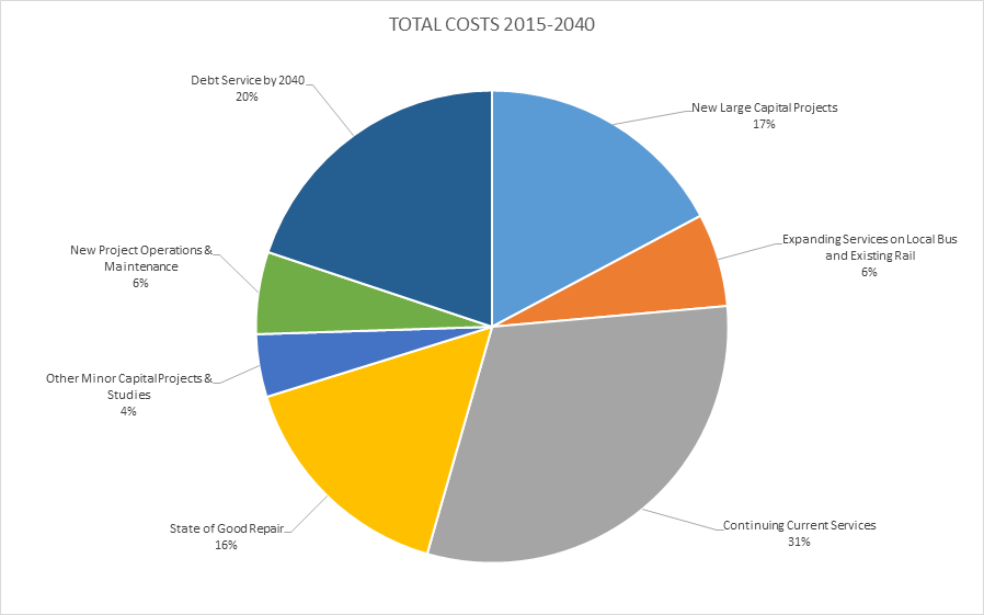
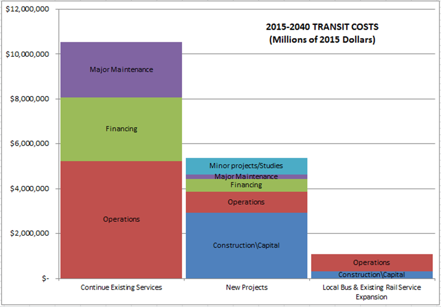
The Plan identified one billion dollars to expand services on existing local bus and rail. This made up almost one-fifth of new expenditures. The breakdown by phases for service expansion is as follows.
- Phase 1: 28% of new funds used for service expansion of the current transit system.
- Phase 2: 18% of new funds used for service expansion of the current transit system.
- Phase 3: 15% of new funds used for service expansion of the current transit system.
Transit needs identified in the RTP included frequency of existing local bus and rail services, expanded hours of operation, and expanded transit coverage area. There were two billion dollars identified to build enhanced bus and bus rapid transit (BRT) projects. Many of these projects focused on enhancing core bus service routes by providing more frequent service. Ultimately, even new capital projects were largely projects that improved bus service. The RTP also proposed nearly one billion dollars to construct new rail lines.
The RTP ensured transit investments are taken care of by specifically allocating approximately three billion dollars to major maintenance of the existing system or State of Good Repair (SOGR). Many physical projects that were previously planned to be built earlier were listed in the “unfunded phase” or deferred to a later phase. This was because funds have been prioritized to be used for the SOGR, in addition to an increased focus on expanded transit service. The RTP also allocated seven billion dollars to continue and expand current services, as well as operate new projects.
The 2015-2040 RTP considered and planed for all modes of travel, and specifically looked to integrate active transportation into the transportation system. Many people walk and bike for their transportation needs—commuting to work, school, and shopping. Over the years, we continued to see growth in the number of trips, as well as the number of users as biking and walking increase along the Wasatch Front. Supporting these modes of transportation has many advantages. Bike and pedestrian activity is consistent with many of the RTP goals and, additionally, promotes a healthy lifestyle, increases transportation options, supports a healthy environment through better air quality, and makes a positive contribution to the economy.
The 2015-2040 RTP addressed the existing active transportation network, as well as those routes that are anticipated as part of the proposed future network, which can be viewed via the interactive map. Planning for active transportation was completed through two WFRC plans, including the 2015-2040 Base Bicycle Network, which included all local and county plans, and the 2015-2040 Regional Priority Bicycle Network.
The 2015-2040 RTP bicycle networks included many critical connections and looked to make regional connections and support local communities. This growing network would increase access and give the current user the ability to capitalize on more routes, encourage additional residents to utilize the system, and enhance the safety of bicycle and pedestrian commuters as well as recreational users. Adding connections and new routes gave the existing active transportation system more value.
WFRC participated in many active transportation planning efforts, understanding that travel choices are critical to maintaining and building an efficient and integrated transportation system for the region. Overall, the 2015-2040 RTP placed a growing emphasis on active transportation, considering access, convenience, and safety of bicycle and pedestrian path users a major priority among the bike plans and integrated within the roadway and transit projects.


