A Station Area Plan (SAP) is intended to promote shared objectives such as housing availability and affordability, access to opportunities, sustainable environmental conditions, and transportation choices and connections. As a result of the 2022 state Legislative session, HB462 (titled Housing Affordability Amendments, a summary of which is located here) passed and was signed into law requiring a city that has a fixed-guideway public transit station (rail or BRT) to develop a Station Area Plan for that station and update its general plan and zoning to implement the Station Area Plan.
HB462 also requires that Station Area Plans promote the following principles:
- Increases the availability and affordability of housing, including moderate income housing.
- Promotes sustainable environmental conditions.
- Enhances access to opportunities.
- Increases transportation choices and connections.
Station Area Plans support many of the goals of the Wasatch Choice Vision. The principles listed above pair with the key strategies of the Vision while complimenting its benefits. In particular, Station Area Plans uplift our choices to quality transportation, affordable housing, access to economic opportunities, and more. They ensure that we have a plan as we continue to look ahead to address tomorrow’s growth while preserving today’s quality of life.

Pursuant to HB462, Metropolitan Planning Organizations are responsible for certifying Station Area Plans. A form is available for communities to use to submit Station Area Plans and relevant resolutions to the Wasatch Front Regional Council for review and certification. Additionally, WFRC has adopted a policy for certifying SAPs.
The Wasatch Front Regional Council can provide technical assistance to help communities implement HB462 in partnership with the Governor’s Office of Economic Opportunity, the Utah Transit Authority, and the Mountainlands Association of Governments.
Applications for technical assistance are being accepted for consideration on an ongoing basis. If you have any questions, please contact Megan Townsend, mtownsend@wfrc.org.
- Farmington FrontRunner Station Area Plan (Certified by WFRC on 10/27/22)
- Salt Lake City Ballpark Station Area Plan (Certified by WFRC on 1/26/23)
- Roy FrontRunner Station Area Plan (Certified by WFRC on 8/24/2023)
- South Jordan 4800 W Old Bingham Hwy TRAX Station Area Resolution (Certified by WFRC on 8/24/2023)
- Salt Lake City Downtown Stations Prior Actions (Certified by WFRC on 01/25/2024)
- Midvale Center and Fort Union Station Areas Plan (Certified by WFRC on 03/28/2024)
- West Jordan & Midvale Station Area Plan (Certified by WFRC on 03/28/2024)
- Clearfield | Clearfield FrontRunner Station | Due December 20, 2022
- Midvale | Midvale Center & Midvale Fort Union Stations | Due October 7, 2022
- Murray and Millcreek I Murray North Station I Due November 10, 2022
- Roy I Roy Station I Due November 4, 2022
- West Jordan & Midvale | Bingham Junction, Historic Gardner, & West Jordan City Center Stations | Due September 28, 2022
- West Jordan | 5600 W. Old Bingham Hwy TRAX station | Due March 14, 2023
- Ogden City | 32nd & Harrison, 36th & Harrison, WSU Main Campus, WSU Student Housing, Dee Events Center Station Area Plan | Due March 25,2024
- West Valley City | Decker Lake, Redwood Junction, & River Trail TRAX Station Area Plan | Due April 8, 2024 at 11:00 am
- Woods Cross City | Woods Cross FrontRunner | Due April, 22, 2024 at 11 am
Station Area Planning Certification Requirements Checklist
Use this checklist to do a preliminary assessment to determine whether your station area plan complies with Utah House Bill 462.
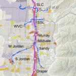
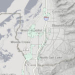
Required Station Area Plans, with Station Buffers
This map illustrates the stations along the Wasatch Front that require Station Area Plans, and the buffer zone around each where the requirement applies. SAPs are a very important catalyst toward realizing the Wasatch Choice Vision and its quality of life benefits. View the interactive SAP map (with station buffers).
Access to opportunities, also referred to as accessibility or ATO, is a way to measure how well people can connect to basic needs and amenities including jobs, schools, grocery and other retail, parks, community centers, recreation, and entertainment. Station Area Plans leverage land-use solutions that improve Access to Opportunities, including:
- Growth centers near high-capacity transportation,
- Higher densities,
- Intermixing homes and jobs, and
- Street design that encourages local investment along the street.
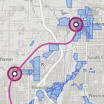
Regional Transportation Plan (RTP) Map
Every four years, WFRC adopts an updated Regional Transportation Plan (RTP) – the long-range plan for roadway, transit, and active transportation projects over the next 20-30 years. This critical work is done in close collaboration with our transportation agency and local government partners. The RTP creates a framework for understanding and responding to future uncertainties and external forces that have the potential to alter our transportation, land use, and economic systems.
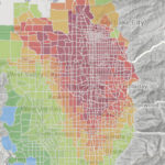
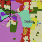
Housing and Transit Reinvestment Zones (HTRZ) Map
Housing and Transit Reinvestment Zones are a development tool that helps address Utah’s housing crisis by facilitating mixed-use, multi-family and affordable housing development within a 1/3-mile radius of fixed commuter rail stations (FrontRunner). Amongst the many benefits, HTRZ’s promote higher public transit use, increase housing choice and affordability, and increases access to employment and education opportunities.
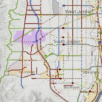
Community Development Areas (CDA) Layer – Wasatch Choice Vision Map
Community Development Areas are public financing tools. They temporarily use the increase in tax revenue spurred by land reinvestment in order to pay for things like infrastructure improvements. By doing so they further encourage land reinvestment.
The link above opens to the Economic Development tab of the Wasatch Choice interactive map where CDA boundaries are one of the layers that are shown. Turn off the other layers to view just the CDA zones. The CDA boundaries are also an optional layer that can be turned on in the HTRZ map described above. The most recent CDA layer (2021) is found within the statewide Tax Entities dataset, downloadable from UGRC.
Generalized Future Land Use (GFLU) Map
The Generalized Future Land Use (GFLU) layer compiles and standardizes city and unincorporated area general plans into a region-wide GIS layer of allowable land uses and residential and commercial development intensity limits. This layer guides and constrain future real estate development activity simulated with REMM.

WFRC Station Area Plan Certification Policy
The provisions of HB462 require the Wasatch Front Regional Council (WFRC) to review and certify, if appropriate, Station Area Plans (SAP) prepared by cities within the WFRC area. HB462 specifies that the applicable metropolitan planning organization, in consultation with the applicable public transit district, shall review the documentation submitted by cities to WFRC for certification under the provisions of the statute to determine the municipality’s compliance with the statutory requirements; and provide written certification to the municipality if the applicable metropolitan planning organization determines that the municipality has satisfied the requirement(s) for Station Area Plans.
A Station Area Plan (SAP) is intended to promote shared objectives such as housing availability and affordability, access to opportunities, sustainable environmental conditions, and transportation choices and connections. As a result of the 2022 state Legislative session, HB462 (titled Housing Affordability Amendments, a summary of which is located here) passed and was signed into law requiring a city that has a fixed-guideway public transit station (rail or BRT) to develop a Station Area Plan for that station and update its general plan and zoning to implement the Station Area Plan.
HB462 also requires that Station Area Plans promote the following principles:
- Increases the availability and affordability of housing, including moderate income housing.
- Promotes sustainable environmental conditions.
- Enhances access to opportunities.
- Increases transportation choices and connections.
Station Area Plans support many of the goals of the Wasatch Choice Vision. The principles listed above pair with the key strategies of the Vision while complimenting its benefits. In particular, Station Area Plans uplift our choices to quality transportation, affordable housing, access to economic opportunities, and more. They ensure that we have a plan as we continue to look ahead to address tomorrow’s growth while preserving today’s quality of life.
Pursuant to HB462, Metropolitan Planning Organizations are responsible for certifying Station Area Plans. A form is under development for communities to use to submit Station Area Plans and relevant resolutions to the Wasatch Front Regional Council for review and certification. The form will be located here once available.
The Wasatch Front Regional Council can provide technical assistance to help communities implement HB462 in partnership with the Governor’s Office of Economic Opportunity, the Utah Transit Authority, and the Mountainlands Association of Governments.
We expect the next application deadline to be in September. Please check back for more information in early August. If you have any questions, please contact Megan Townsend, mtownsend@wfrc.org.
Required Station Area Plans, with Station Buffers
This map illustrates the stations along the Wasatch Front that require Station Area Plans, and the buffer zone around each where the requirement applies. SAPs are a very important catalyst toward realizing the Wasatch Choice Vision and its quality of life benefits. View the interactive SAP map (with station buffers).
Access to opportunities, also referred to as accessibility or ATO, is a way to measure how well people can connect to basic needs and amenities including jobs, schools, grocery and other retail, parks, community centers, recreation, and entertainment. Station Area Plans leverage land-use solutions that improve Access to Opportunities, including:
- Growth centers near high-capacity transportation,
- Higher densities,
- Intermixing homes and jobs, and
- Street design that encourages local investment along the street.
Regional Transportation Plan (RTP) Map
Every four years, WFRC adopts an updated Regional Transportation Plan (RTP) – the long-range plan for roadway, transit, and active transportation projects over the next 20-30 years. This critical work is done in close collaboration with our transportation agency and local government partners. The RTP creates a framework for understanding and responding to future uncertainties and external forces that have the potential to alter our transportation, land use, and economic systems.
Housing and Transit Reinvestment Zones (HTRZ) Map
Housing and Transit Reinvestment Zones are a development tool that helps address Utah’s housing crisis by facilitating mixed-use, multi-family and affordable housing development within a 1/3-mile radius of fixed commuter rail stations (FrontRunner). Amongst the many benefits, HTRZ’s promote higher public transit use, increase housing choice and affordability, and increases access to employment and education opportunities.
Community Development Areas (CDA) Layer – Wasatch Choice Vision Map
Community Development Areas are public financing tools. They temporarily use the increase in tax revenue spurred by land reinvestment in order to pay for things like infrastructure improvements. By doing so they further encourage land reinvestment.
The link above opens to the Economic Development tab of the Wasatch Choice interactive map where CDA boundaries are one of the layers that are shown. Turn off the other layers to view just the CDA zones. The CDA boundaries are also an optional layer that can be turned on in the HTRZ map described above. The most recent CDA layer (2021) is found within the statewide Tax Entities dataset, downloadable from UGRC.
Generalized Future Land Use (GFLU) Map
The Generalized Future Land Use (GFLU) layer compiles and standardizes city and unincorporated area general plans into a region-wide GIS layer of allowable land uses and residential and commercial development intensity limits. This layer guides and constrain future real estate development activity simulated with REMM.