
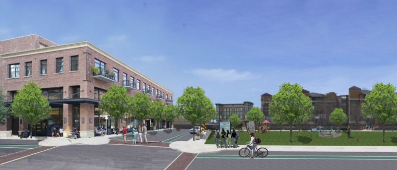
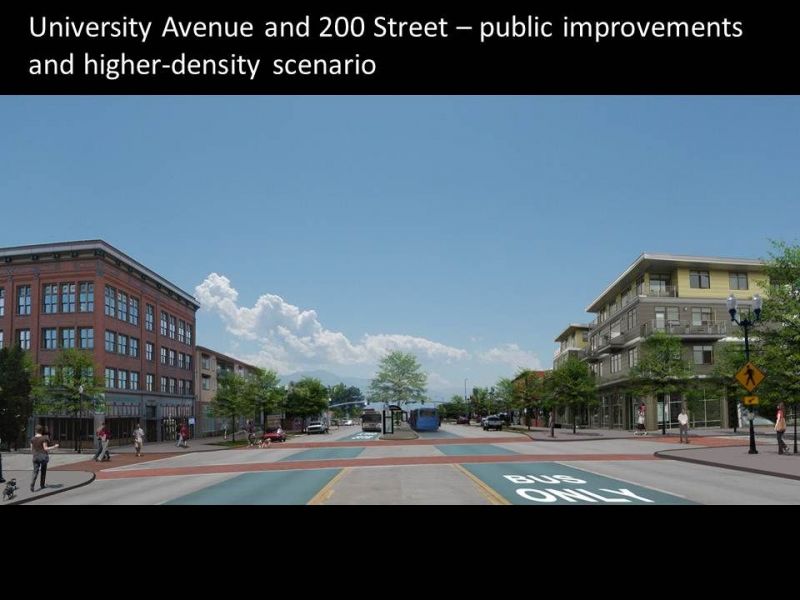
Salt Lake City’s downtown streetcar is envisioned to enhance and accelerate walkable, transit-oriented redevelopment in the city’s downtown core and the Granary District to the south and west. In downtown, the streetcar will serve as a pedestrian circulator, while it is expected to spark economic development in the Granary.
Read MoreThe Envisioning Centers process enabled residents, business owners and other stakeholders to participate in a visioning effort to explore redevelopment ideas for the land surrounding the potential streetcar route. Participants were interested in emphasizing the identity of the areas the streetcar will pass through, highlighting the emerging arts scene, the Granary, and the Central Business District, and creating a sense of neighborhood identity that will attract more residents to the heart of the city. Along with residential development, participants envision corresponding services and places to play and relax, to make daily life along the streetcar corridor pleasant and convenient. Interest in maintaining the warehouse feel of the Granary is high, with most participants supportive of repurposing existing warehouse space as feasible.
The exploration of redevelopment concepts occurred as Salt Lake City and the Utah Transit Authority (UTA) began the alternatives analysis for the streetcar. Those involved in the alternatives analysis and the Envisioning Centers process partnered in working group meetings, as well as at a public open house held at a downtown grocery store. The information collected and concepts developed will inform future work along the streetcar corridor.
For additional information regarding the demonstration sites, please contact Ted Knowlton.
The highest concentrations of homes affordable to a four-person household with an income of 80 percent of the county’s area median income are in the eastern tip of the TRAX line, east of Trolley Square, and the southwestern corner from the City Center stop to 900 South.


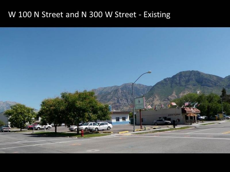
Meadowbrook Station is a light rail stop in an older industrial area near the center of the Salt Lake Valley. It has the potential to provide residents and business owners convenient rail access to downtown, the University of Utah, and many other regional centers in our valley.
Read MoreThe Meadowbrook community leveraged the Envisioning Centers process and Wasatch Choice Toolbox. A collaborative process engaged citizens and nonprofits (including those serving the underrepresented) alongside both developers and city and county leaders to identify and explore common hopes and dreams, and create scenarios that captured ideas and opportunities.
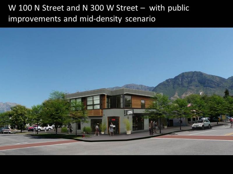
The scenarios are market responsive—they include the kinds of homes and places that people will need and that developers can build. The Housing Opportunities Analysis and a market study provided an understanding of the possibilities. They are also fiscally responsible (Envision Tomorrow Plus was used to test this), providing a sound path forward for municipal governments concerned about keeping taxes in check.
The community’s Meadowbrook Station Vision explores two phases of development. The first phase focuses on a Station Community immediately surrounding the Meadowbrook light rail station. The community imagines a vibrant neighborhood, where everyone can not only walk to the train in less than 10 minutes, but also where residents of all income levels have access to a small market and other services, nearby parks, and an elementary school. It also becomes a center for higher education and further employment opportunities, as the community college that is already there expands and more people are drawn to a new place in the heart of our valley.
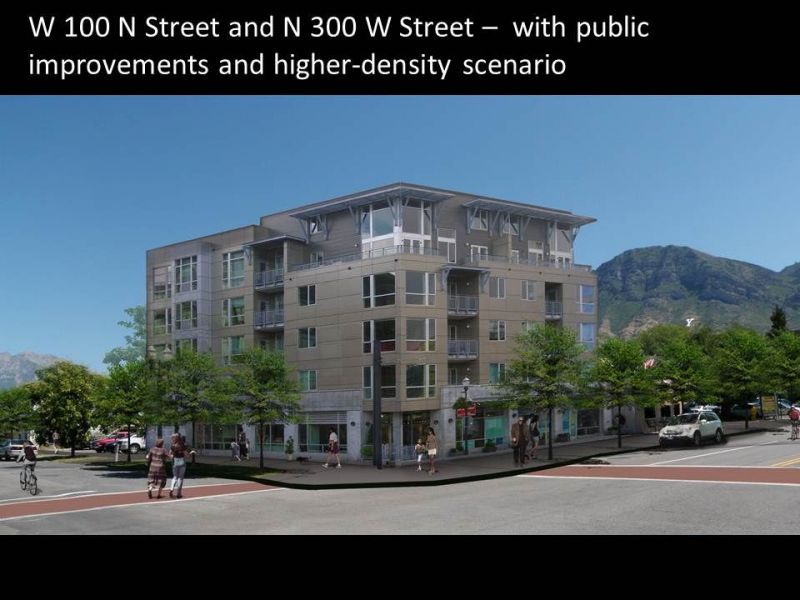
The second phase focuses on what happens when two successful station area communities, Meadowbrook Station and Fireclay Station to the south, begin to grow together. The corridor between them transforms into a promenade lined with homes and businesses. Wide tree-lined sidewalks and bike lanes link the two stations, the parks, the schools, and even provide access to Big Cottonwood Creek, which links residents to the nearby Jordan River Parkway.
Using the Envisioning Centers scenario process and tools included in the Wasatch Choice toolbox, this community has explored a future for itself. Now the City of South Salt Lake and Salt Lake County are employing implementation tools from the Wasatch Choice toolbox—the Form-Based Code Template and Implementing Centers checklists—to create policy that removes barriers and encourages the kind of growth that this community envisions.
As policy updates are happening and barriers to development are removed, there are already tremendous things happening on the ground—134 mixed income apartments were planned in the Meadowbrook area with units to serve low income groups including refugees, disabled persons, and at-risk youth, and these units are getting built.
For additional information regarding the demonstration sites, please contact Ted Knowlton.
Meadowbrook
West Temple
Creek
While eight Section Eight Vouchers are being used in and around the Meadowbrook Demonstration Site, only about half of them are within a half mile of a transit stop.


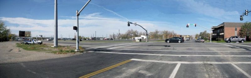
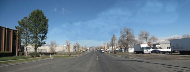
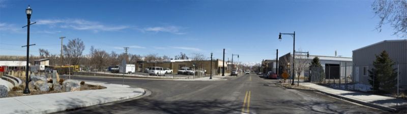
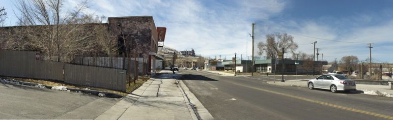
Historically a company town for Kennecott Copper, Magna lies on the west side of the Salt Lake Valley and provides significant opportunities for nearby larger metropolitan centers.
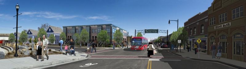
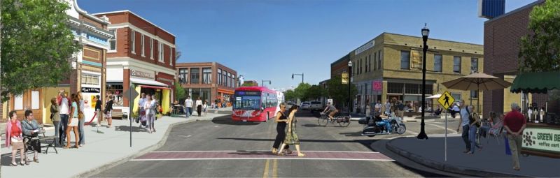
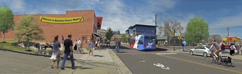
Read MoreMagna’s Main Street, lined with quaint century-old brick buildings, was once the center of a Kennecott Copper company town and a vibrant shopping district. Though the street has since experienced decades of decline, recent public investments along Main Street have been significant and include a new library, senior center, and pedestrian-scale street enhancements, including new curb and gutter, wide new sidewalks, street trees, and lighting. A bus rapid transit line connects the township to the region’s light rail system, giving Magna convenient access to downtown Salt Lake City and other regional destinations.
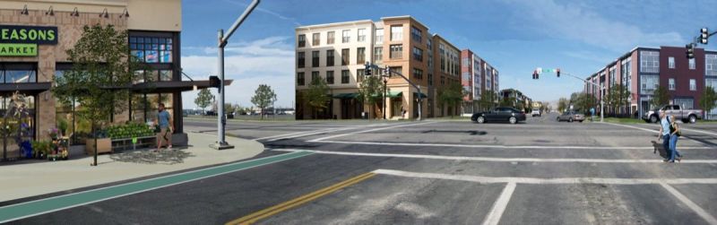
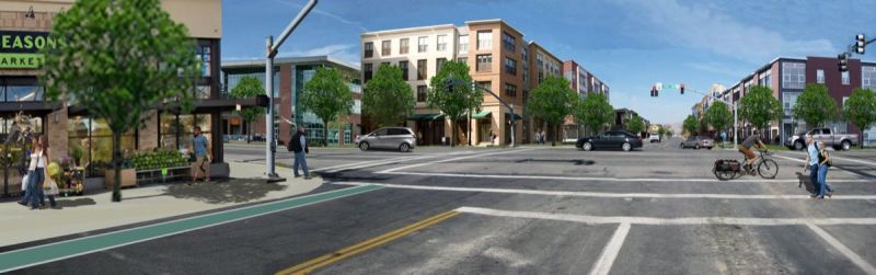
The Envisioning Centers process enabled residents and Main Street business owners to explore options for Magna’s Main Street area. Together, they developed a vision, Cultivating Community, Captivating Main Street, which emphasizes Magna’s historic character and existing assets, and a desire to provide a family-friendly place for living, shopping, and entertainment.
The community is moving forward with its vision on several fronts. Informed by the visioning process, Salt Lake County convened a group that is working from the Form-Based Code Template in the Wasatch Choice Toolbox to develop a form-based code for the Main Street area. A citizen implementation committee has commenced work on several initiatives to bring investment and people to Main Street, including a farmers’ market and a resource guide. NeighborWorks, a national capacity builder with a successful track record in the Salt Lake Valley, will help grow leadership capacity in Magna.
For additional information regarding the demonstration sites, please contact Ted Knowlton.
Within the Magna Demonstration Site, a majority of the homes were valued below $159,910 in 2011, making them affordable to four-person households at 50 percent of the area median income or below. Only a few homes in the northeastern section of the catalytic site valued higher.


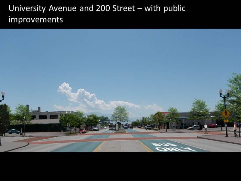
The area around Provo’s Intermodal Hub is currently undergoing substantial changes. Provo is the county seat and center of Utah County, which is growing rapidly and is projected to nearly double in population and employment by the year 2040.
Read MoreKey to the current growth and development in the downtown area are new investments in public transportation by way of a new commuter rail line and stop just south of the downtown and a new bus rapid transit system that will connect the new commuter rail stop with Brigham Young University and Utah Valley University in Orem. These new transportation investments have the potential to attract the development of thousands of new households and jobs in the downtown area, and also provide increased access for workers, students, and residents.
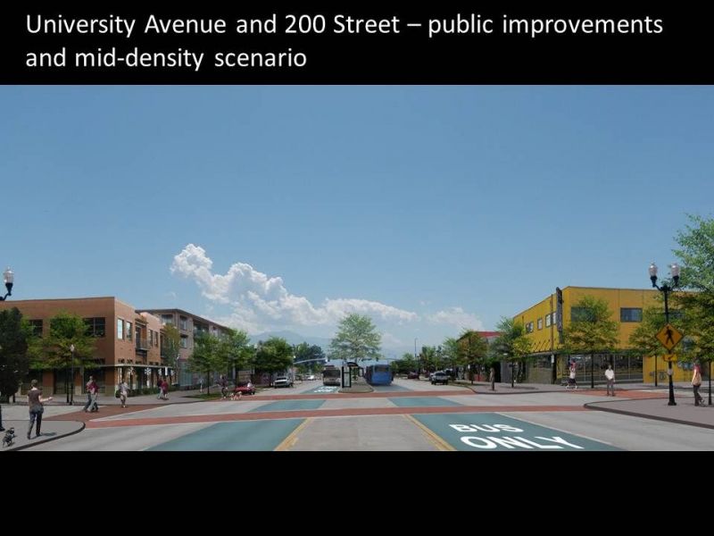
During the Envisioning Centers process, several analyses were undertaken to assess the capacity and demand for residential and commercial development in downtown Provo. Some of the key factors that were considered included demographics, market demands, and physical capacity criteria, such as infrastructure and land constraints.
In-line with the Envisioning Centers process and working with our stakeholder group, Envision Utah created four scenarios with differing land uses for the Provo study area to meet the expected growth. The scenarios were derived from our stakeholders’ meetings in which stakeholders from the City and community took part in mapping exercises to help guide and to provide input about the future development of Provo. Some of the stakeholder maps displayed fairly aggressive growth with many high-density land uses while other stakeholder maps displayed a more moderate vision of growth.
The scenarios were modeled and refined using Envision Tomorrow Plus to reflect market research and to help create a “Vision Scenario” for the Downtown Provo area, which was then vetted by the stakeholder group.
Today, progress is being made towards the vision. It is being implemented by way of a newly remodeled Utah Valley Convention Center, which has inspired local business owners to dress up their storefronts with new paint, brick, and mortar.
For additional information regarding the demonstration sites, please contact Ted Knowlton.
While more than 67 percent of the low wages jobs in Provo are south of the Provo Demonstration Site, this is a large, expansive area, where the northeastern section of the catalytic site has almost 29 percent of the low wage jobs in a much smaller area. The concentration of low wage jobs is an indicator of the need for affordable rental housing in the catalytic site.


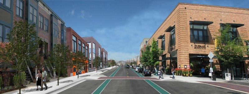
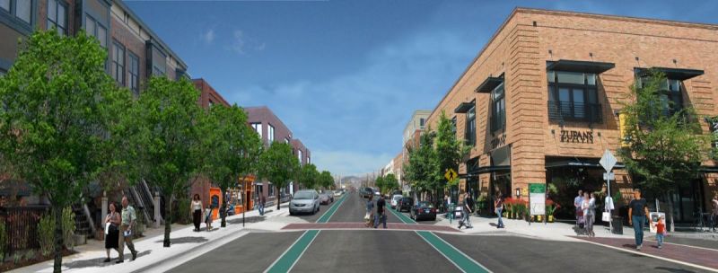
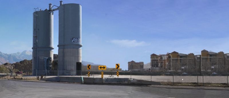
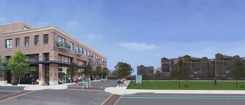
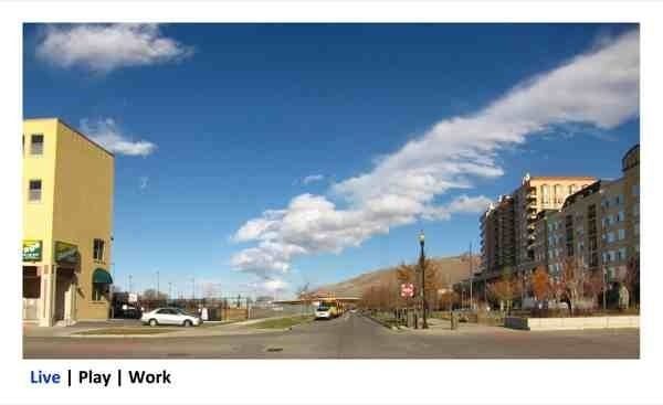
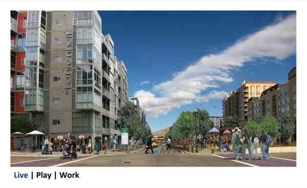
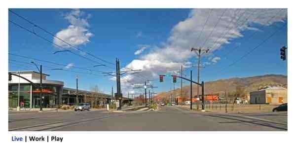
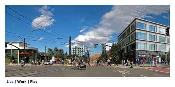
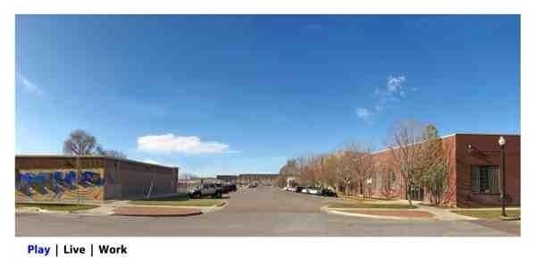
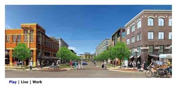
Salt Lake City’s Depot District lies on the western edge of downtown and encompasses both land around Salt Lake Central Station, where the region’s transit systems converge, and land directly north of the station and west of the Gateway development. Historically surrounded by a rail yard and freeway viaducts, the land was largely ignored for decades. Now, with the viaducts shortened and the rail consolidated, the land is poised for growth.
Read MoreThe Envisioning Centers process engaged the pubic and community leaders in an exploration of development options for the area and served as an early test case for the Wasatch Choice Toolbox. Live | Work | Play, the vision created by citizens and stakeholders, emphasizes creating a neighborhood west of the existing Gateway development, with a focus on housing, day-to-day services, grocery store, schools, and places to play. A focus on arts and entertainment provides vibrancy along a festival street that connects commuters to downtown from the trains. Additionally, a job center adjacent to the Salt Lake Central Station provides direct transit access to employment. Challenges include redeveloping successfully without displacing current residents and business owners.
Interest in the Depot District is high, and the vision is being implemented. Two mid-rise apartment buildings are currently under construction west of Gateway, helping to make 500 West feel like a residential street in an urban neighborhood.
For additional information regarding the demonstration sites, please contact Ted Knowlton.
While a much of the minority renter-occupied units are within a half mile of transit around the Depot District Demonstration Site, the densest concentrations are outside the catalytic site and on the edge of the half mile radius.


Already the primary destination for shopping, employment, and entertainment in southern Salt Lake County, downtown Sandy is envisioned as a thriving mixed-use urban center. A walkable main street anchored on one end by Sandy City Hall and on the other end by South Towne Mall will create a vibrant environment. The TRAX light rail stop will be linked through the area to the nearby Frontrunner commuter rail stop via a downtown circulator. And skiers will be able to find lodging, food, and shopping, while easily accessing the nearby Wasatch Mountain resorts using public transportation.
Read MoreExisting destinations include Jordan Commons, South Town Expo Center, South Town Mall, Jordan High School, the Real Salt Lake Stadium, BD Medical, Workers Compensation Fund, and Sandy’s City Hall. This area also is connected to the Dimple Dell Trail and the Jordan River Parkway.
For additional information regarding the demonstration sites, please contact Ted Knowlton.