Models: Tools for Forecasting the Future of Our Region
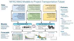
WFRC employs sophisticated transportation and land use modeling tools that help support decision-makers, agency staff, and the public with plausible, insightful forecasts to best inform planning for our Region. The primary tools are the Wasatch Front Travel Demand Model and the Real Estate Market model described below. Together these models enable detailed analyses and comparisons of how well the transportation and land use plans that implement the Wasatch Choice Vision perform, as well as other possible future scenarios for our region.
As transportation and land use are mutually dependent, forecasting for both of these regional components must work in tandem in order to optimally support the development, selection, and prioritization of future transportation projects intended to meet future needs. Similarly, the integrated WFRC/MAG modeling tools are useful for exploring local land use policies such as those that promote city and town centers.
Projected measures produced with assistance from transportation and land use models include:
- future population, household, and employment distributions;
- travel patterns and mode share;
- future vehicle and transit volumes and their relationship to the capacity of existing facilities and services;
- travel times and comparative accessibility to workplaces and other key destinations; and
- key inputs to air quality mobile-source emission models
Developing and maintaining travel and land use models is a best practice for regional planning. But it also fulfills requirements and expectations needed to continue to receive our region’s share of federal transportation funding. Accordingly, WFRC’s modeling processes comply with federal law (FAST Act, MAP21, and Clean Air Acts) as well as guidance provided by the US Department of Transportation (USDOT), the Federal Highway Administration (FHWA), the Federal Transit Administration (FTA), and the Environmental Protection Agency (EPA).

Since 2000, WFRC has partnered with our Mountainland Association of Governments (MAG) to develop and support a shared, regionwide travel demand model called the Wasatch Front Travel Demand Model (WF-TDM).
The WF-TDM is a modified 4-step “trip-based” travel model that incorporates a travel time feedback loop in order to evaluate roadway congestion costs in its distribution of trip origins and destinations and its travel mode choice modules. The model calculates roadway volumes, travel speed indicators, transit route boardings, and regional statistics including vehicle miles traveled (VMT), vehicle hours traveled (VHT), transit/auto/non-motorized mode shares, and trip length costs.
The travel model includes the phased, fiscally-constrained 2023-2050 RTP roadway and transit projects and the official traffic analysis zone (TAZ)-level socioeconomic forecasts for the Region. WFRC and MAG have calibrated the model’s parameters to reflect local travel behavior patterns reported in the Utah Travel Study household survey (trip rates, trip lengths, time of day of trip, mode of travel, etc.) and validated the model’s results with observed travel conditions (transit ridership, roadway volumes, and roadway speeds) for the model’s base year, 2019. Additional processes, including external review, are used to validate the reasonableness of future year travel projections.

The WF-TDM is under constant development. Various versions and iterations of the model exist, with the most relevant described below:
- v9.1.1 — current version of the travel model; reflects the Amendment #3 changes to the WFRC Regional Transportation Plan; a supplemental socioeconomic forecast for the MAG area of the region (Utah County); an updated Workplace Access to Opportunity (ATO) calculation methodology; and updates to the accompanying Viz Tool for exploring model results. (released May 27, 2025)
- v9.1.0 — reflects the Amendment #2 changes to the WFRC Regional Transportation Plan and draft Amendment #2 to the MAG Regional Transportation Plan; inclusion of the vizTool data viewer
- v9.0.2 — reflects the Amendment #1 changes to the WFRC & MAG Regional Transportation Plans (adopted May/June 2024)
- v9.0.1 — minor updates and bug fixes to the v9.0.0 model
- v9.0.0 — base for the current version of the travel model; foundation for the current traffic volume forecasts for the Wasatch Front Region; adopted as the official version of the 2023-2050 RTP on May 25, 2023
- v8.3.2 — previous version of the travel model; foundation for the previous traffic volume forecasts for the Wasatch Front Region; released on February 2, 2022
Detailed documentation for each of the model versions is described in the online documentation.
Currently, WFRC is undergoing the development of v9.2. These versions will introduce mode choice and truck model enhancements as well consideration of the 2023 household travel survey.
To request a copy of the current or previous model, please contact Suzie Swim.
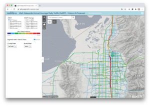
The Wasatch Front Regional Council’s (WFRC) preliminary forecasted traffic volumes through the year 2050 in the Ogden-Layton and Salt Lake-West Valley urbanized areas can be found via the Utah Statewide Annual Average Daily Traffic (AADT) – Historic & Forecast web map. The ‘Advanced Version’ view of the web map includes the population and employment forecasts in addition to the Regional Transportation Plan projects through 2050 for reference.
The expected margin of error for the values shown on the map, which depends on the magnitude of the volume, range from 10 to 20 percent. These ranges are generally based on acceptable confidence intervals found in the Federal Highway Administration’s (FHWA) Model Validation and Reasonableness Checking Manual. For environmental studies or alternatives analysis, WFRC recommends using the travel model directly, but still tempering results by observed values, so that appropriate comparisons can be made among alternatives. The forecasts found on the website generally assume completion of the current WFRC Regional Transportation Plan (RTP). WFRC assumes no liability for others’ use of these traffic forecasts, including both the individual values and ranges of values obtained from the margins of error.
For additional information regarding traffic data, please contact Suzie Swim.
Helpful Links and Downloads
- Utah Statewide Annual Average Daily Traffic (AADT) – Historic & Forecast web map
- Utah Statewide Annual Average Daily Traffic (AADT) – Historic & Forecast previous web map
- Utah Department of Transportation Observed Average Annual Daily Traffic Volumes
- AADT from UDOT Data Portal (current and historical)
Additional resources relating to the WF-TDM are listed below, as well as a short description.
- WF-TDM Documentation (model documentation for each version)
- Current Traffic Volume Map (Utah AADT Historic and Forecast map)
- Previous Traffic Volume Map (Utah AADT Historic and Forecast map)
- UtahMUG (Utah model users group website and blog)
- 2023 Household Travel Survey (household travel survey documentation and visualization tool)
- 2012 Household Travel Survey (household travel survey final report)
- WF-TDM vizTool (visualization tool for raw model outputs — beta version)
The Real Estate Market Model (REMM) relies on best available resources to project future residential and employment-related development activity using the UrbanSim modeling platform. In order to accurately model future years, REMM is first calibrated to best reflect the base year of the adopted RTP, currently 2019. Critical inputs to REMM’s consideration of available land and profitability of new and redevelopment activity include:
- A region-wide parcel land use and valuation database;
- An inventory of local government general plans;
- The results of a multi-year scenario-based visioning exercise;
- A synthesized household population dataset for the model’s base year (2019) based on Census data;
- Address geocoded employment totals from the Utah Department of Workforce Services (DWS);
- County-level employment and population control total projections, sourced from the University of Utah’s Kem C. Gardner Policy Institute;
- Public and private sector expert advisors; and
- ‘Physical constraint’ map layers that depict areas where future development is prohibited or not practical due to steep terrain, wetlands, mining, or public lands (formal designations or ownership).
These household and job distribution projections inform future trip generation in the regional TDM. And in turn, REMM factors travel accessibility derived from the travel model into its predictions of land development activity.
The current version of REMM is v2.x
WFRC and MAG hosted a expert peer review of REMM and its related processes in August 2019. Three land use modelers from comparable MPOs (Albuquerque, Detroit, Phoenix) were provided with REMM 1.0 documentation in advance of a 2 day in-person review seminar that featured presentations from and discussion among the panelists and WFRC/MAG area stakeholder agencies. The review concluded that REMM is well within best practices for land use modeling and recommended potential future areas of enhancement (view 2019 REMM Peer Review report).
Related Resources:
To request a copy of the current or previous model, please contact Suzie Swim.
As inputs to planning efforts, WFRC develops and maintains population, housing, and employment estimates and projections at various geographic scales.
Downloadable socioeconomic forecast datasets from the 2023-2050 Regional Transportation Plan are available from data.wfrc.org.
WFRC is also an affiliate of the State Data Center network established by the US Census Bureau and closely coordinates with other data providers, including the Kem C. Gardner Policy Institute at the University of Utah, US Census Bureau, and Utah Department of Workforce Services.
In addition to internal uses, WFRC socioeconomic data are also used by local planners, consultants, and other interested parties for use in their planning and analysis.
Note that for the ‘City Area’ projection datasets listed below, these are created from projections for groups of smaller traffic analysis zones (TAZ) whose boundaries roughly align with each city’s current boundary. As TAZs do not align perfectly with current city boundaries, the ‘city area’ summaries are not projections specific to a current or future city boundary, but the ‘city area’ summaries may be suitable surrogates or starting points upon which to base city-specific projections.
For additional information regarding socioeconomic data, please contact analytics@wfrc.org.
Socioeconomic Forecasts Datasets
- Household Projections (City Area
-
Household Projections (TAZ)
-
Population Projections (City Area)
-
Population Projections (TAZ)
-
SE Comparison RTP19 – RTP15
-
Community Focus Areas
-
All Jobs Projections (City Area)
-
All Jobs Projections (TAZ)
-
Industrial Jobs Projections (City Area)
-
Industrial Jobs Projections (TAZ)
-
Nontypical Jobs Projections (City Area)
-
Nontypical Jobs Projections (TAZ)
-
Office Jobs Projections (City Area)
-
Office Jobs Projections (TAZ)
-
Retail Jobs Projections (City Area)
-
Retail Jobs Projections (TAZ)
-
Typical Jobs Projections (City Area)
-
Typical Jobs Projections (TAZ)
Helpful Links and Downloads
-
National Historical GIS Data (UMN’s user friendly site for all Census data!)
Additional resources relating to REMM are listed below, as well as a short description.
- REMM Documentation (model documentation for version 1.0)
- Peer Review Report (peer review report to verify best practices)
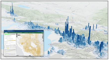
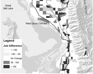
- Household and Job Forecasts Map (map to visualize current and forecasted house and job locations)
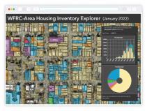
- Housing Inventory Explorer (map to explore housing types at the parcel level)
- Gardner Policy Institute Data (population estimates and forecasts)
- National Historical GIS Data (UMN’s user friendly site for all Census data!)
- US Census Data (a place to explore the US’s census data)
Presentations
WFRC Analytics often has the opportunity to present information regarding our models and forecasting tools at conferences or meetings. Past presentations serve as an excellent resource into how our modelling and forecasting tools assist in planning efforts. Below are some of the meaningful presentations our team has presented within the last few years. Many of the presentations were presented at in forums like the Utah Model Users (UtahMUG) or the Utah Data Engineers and Scientist in Transportation (uDEST). Many more presentations were given at conferences like those held by the Institute of Transportation Engineers (ITE), Utah Tranportation Conference (UTC), the Association of Metropolitan Planning Organizations (AMPO), and others. In addition, some presentations that were given at colleges or within house at WFRC itself are also listed.
- Visualizing Transportation Planning Data through Interactive Web Applications (ITE Mountain District)
- Harnessing ArcGIS Pro, Python Notebooks, & Github to Wrangle Land Use Model Inputs (uDEST)
- Updating Bus Speed Ratios in R (uDEST)
- Utah Bike Model Roadmap: Where we are? and Where we are going? (UtahMUG)
- Planning Information at Your Fingertips (ITE Utah Section)
- Growth-Related Planning Resources (WSU Walker Center)
- Regional Projections Update – Wasatch Choice Centers Refinement (RGC TAC)
- Modeling at WFRC (WFRC)
- WFRC Updates (ITE Utah Section)
- 2022 TAZ Structure (UtahMUG)
- Wasatch Front Travel Demand Model version 8.3.2 (UtahMUG)
- For presentations given before 2021, please contact Suzie Swim.
The Wasatch Front TDM and REMM are updated every four years in sync with the four-year RTP cycle. These models serve the Salt Lake, Ogden-Layton, and Provo-Orem Urban Areas. For more information on any of the above, contact the WFRC Analytics Group.