Major changes were made to the version 9 Traffic Analysis Zones (TAZ), including:
Internal TAZ were split to increase the model’s geographic resolution.
TAZ boundaries were modified to better align with underlying land uses and planning boundaries.
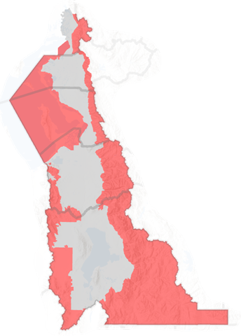
The geographic coverage area was expanded to encompass the entire county for Davis, Salt Lake, and Utah counties. Weber County was expanded up to the ridgeline of the east canyon/mountain areas of the WFRC planning domain but does not include the Ogden Valley area. Box Elder was expanded to encompass up to the ridgeline of the east canyon/mountain areas of the WFRC planning domain.
Figure 1 and Figure 2 show the expanded geographic area and the difference in TAZ boundaries between version 9 and version 8.
The changes resulted in the addition of 688 internal TAZ. The new internal TAZID range for each county was updated to account for the new zone configuration. A buffer of 54 zones was inserted after the last internal TAZ to allow for future internal TAZ expansion within the max used-zone value.
Table 1: Internal TAZ Comparison
County
v9 Count
v8 Count
Change
v9 TAZID Range
v8 TAZID Range
Box Elder
153
135
18
-152
-134
Weber
428
280
148
-427
-279
Davis
324
231
93
-323
-230
Salt Lake
1311
1127
184
-1310
-1126
Utah
1330
1085
245
-1329
-1084
Total
3546
2858
688
-3545
-2872
Unused Zones
54
0
54
-53
NA
The locations and numbering of the external TAZ gateways were revised to reflect the changes of the expanded internal TAZ coverage area and new internal numbering. The external TAZ numbering was grouped and placed after the internal TAZ and a unused zone buffer. For reference, version 8 external TAZ were ordered by county and shuffled in the internal TAZ range, (e.g. Box Elder externals TAZ following after the Box Elder internal TAZ, Weber external TAZ following the Weber internal TAZ, etc.). The external TAZ changes resulted in the addition of 6 external TAZ. (See Changes to External Location and Numbering for more information on external zones.)
Table 2: External TAZ Comparison
County
v9 Count
v8 Count
Change
v9 TAZID Range
v8 TAZID Range
Box Elder
6
5
1
3601-3606
136-140
Weber
3
3
0
3607-3609
421-423
Davis
0
0
0
Salt Lake
6
7
-1
3610-3615
1782-1788
Utah
14
8
6
3616-3629
2874-2881
Total
29
23
6
3601-3629
137-140, 421-423, 1782-1788, 2874-2881
In addition, the following changes were made to the TAZ shapefile:
The TAZ UTM NAD83 projection was fixed to use the standard for Utah rather than the ArcGIS default.
All TAZ boundaries were realigned to county boundaries from the most recent UGRC county dataset.
All internal TAZ topology was checked and corrected to exclude slivers, gaps, and overlaps.
External zone polygons (i.e. the arbitrary polygons representing the external zones) were removed in the TAZ shapefile.
PRKCSTPERM and PRKCSTTEMP fields were updated (see Parking Costs for additional information)
Large, medium, and small district definitions were updated. There are now 26 large districts, 73 medium districts, and 110 small districts. Medium districts still nest within large districts. Small districts were defined based on city area definitions and do not nest within medium districts. All districts were renamed and no longer include commas in the text string.
CITY, COUNTY, and EXTERNAL fields were removed. All model scripts referencing CITY and COUNTY were updated to use CITY_FIPS and CO_FIPS.
A REMM field was added to indicate which TAZs are included in the Real Estate Market Model (REMM), as shown in Figure 3. A value of 1 indicates that the TAZ is part of the REMM area.
Code
L =require('leaflet@1.2.0')html`<link href='${resolve('leaflet@1.2.0/dist/leaflet.css')}' rel='stylesheet' />`
The following TAZ-related parameters, located in the0_GeneralParameters.block file, were changed to reflect the version 9 TAZ updates. For comparison purposes, version 8 parameters are also presented.
Used Zones
Table 3: Updated Used Zones
Parameter
v9 Value
v8 Value
Notes
UsedZones
3629
2881
Highest TAZ number used by model
TAZ Ranges
Table 4: Renumbered TAZ Ranges
Parameter
v9 Value
v8 Value
Notes
UsedZones
3629
2881
Highest TAZ number used by model
BoxElderRange
1-153
1-140
Box Elder County Range
WeberRange
154-581
141-423
Weber County Range
DavisRange
582-905
424-654
Davis County Range
SLRange
906-2216
655-1788
Salt Lake County Range
UtahRange
2217-3546
1789-2881
Utah County Range
Dummyzones
3547-3600
2882-3400 (note these are outside of UsedZones)
Placeholder for future TAZ splits
Externalzones
3601-3629
136-140, 421-423, 1782-1788, 2874-2881
External zones
NorthBC
3604-3606
138, 139, 140
North Brigham City external zones
College Zones
Where noted, several colleges were effectively removed from the model in version 9. References to these schools are still in the code base but enrollment was set to zero.