Input Data
Socioeconomic Data
A very minor change was made to the socioeconomic data in Utah County. A few households had been located in the Utah Lake TAZ. These were removed and relocated into nearby TAZ. This change would have very little affect to model results.
Plan Amendment
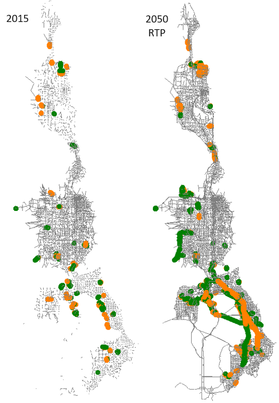
The highway network was updated in the MAG and WFRC areas to reflect the first round of Regional Transportation Plan (RTP) amendments. Additional edits were made in the MAG area to conform with more recent project clarification. The changes to the input highway network are significant, particularly in Utah County, and would most likely affect the travel model’s output. Projects in and around areas of high change may want to do sensitivity tests to better understand the impact that these input network changes may have had on project-level decisions. Figure 1 shows where lanes were added (green) or were taken away (orange) between versions 8.3 and 8.3.1 highway networks.
SR 201 Connection
The highway network was modified at the Salt Lake, Tooele County boundary to provide an independent connection to SR 201 at external 1783. (Note external 1783 existed in the version 8.3 network as a place holder and was not connected to the network in that version.) Externals 1782 and 1783 were moved to improve the connection between the Wasatch Front and USTM travel models. The connecting highway links were also modified to accommodate this change.
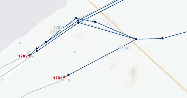
External 1783 is connected to the highway network via a high-speed divided highway (FT=14) beginning in the 2030 fiscally-constrained plan year. In this year, external volume forecasts also begin for external 1783. Prior to 2030, external 1783 is unconnected to the scenario network and the external volume is zero.
The external volume source file and model input files, ’_Source_ExternalTAZ_HistoricalAADT - 2020-04-30.xlsx’ and ‘external_year_vol.csv’ found in ‘1_Inputs\5_External Ext_Vol_Control’, were updated to reflect the changes in externals 1782 and 1783. The forecast annual average daily traffic (AADT) for external 1782 was carried forward from version 8.3. The version 8.3 volume was then divided between the two externals based on information from the Utah Statewide Travel Model (USTM) and professional judgement. The average weekday, single-unit and combo-unit factors for external 1782 were brought up to date with the most current information from the master segment shapefile in the model input folder:
- Average Weekday Factor = 1.057 (was 0.980)
- Single-unit Truck Factor = 7.6% (13%)
- Combo-unit Truck Factor = 9.8% (was 10%)
A summary of the average weekday traffic volumes for externals 1782 and 1783 are shown in the following graphic:
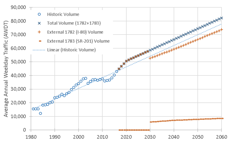
While the forecast AADT is identical to version 8.3, the change in weekday factor increased the input volume into the Wasatch Front model space by roughly 6%. The relative share of these trips also changed with significantly fewer medium trucks and more passenger cars. The share of heavy trucks stayed about the same. The weekday and truck factors for external 1783 were set to be equal to external 1782.
External matrices in =‘1_Inputs\5_External\WF_External’ were also updated through the subarea extraction routine in USTM reflecting the new independent connection to external 1783.